"That was a pretty good spot! How many flushes do you have?" Adam said, as we jumped in the truck after a short scout through a new area.
I glanced at the counters and clock, "I have 6 grouse and 3 woodcock flushes for 2 hours 15 minutes. Decent. I feel like it was better than that."
I find this to be a common type of feeling coming out of woods, particularly out of new areas that are unfamiliar. If you're anything like me, you get lost in the moments spent in the woods chasing those bird driven pups; flushes become blurs, locations and miles blend, and context is faded within the vivid moments. I never want to lose that. However, I also want to continue to improve my knowledge of hunting spots and add great ones to the memory banks. The problem is that sometimes the "numbers" lie, and it is important to trust your instincts as well as employ other tools such as GPS that can provide useful amounts of information and help in your upland pursuits.
|
 |
GPS technology is amazingly accessible and accurate, and most phones now have internal GPS and can be paired with great apps like Trimble Outdoors. Firstly, let me just say, I'm about as barebones as it gets in regards to the technology I like to carry in the woods. I almost never use my GPS for actual navigation, but instead count on my compass and "woodsman skills" to get around; I believe it's dangerous to become too dependent upon GPS to find your way back to the truck. The only reason I carry a GPS in the woods is simple, to find more birds and record a bit more detailed dog/bird data.
I don't want to get too in depth, but I would like to share how it has helped us in our upland hunting. In the specific instance that I opened with, we discovered that this spot was much better than the flush rate suggested. Using the GPS data collected, on the computer back home after dark, with cold brew in hand, we learned that all of our flushes were located in a concentrated location with much of our walking outside this area being unproductive. Also, we found out that this productive area was much closer to another access point so we could shave off significant time and miles. Throughout the coming seasons this "decent" spot has become one of our better small hotspots that contains a concentrated feed stock of dogwood that we missed on our first pass through. Could we have learned this over time without a GPS? Sure. However we dialed in on the zone within two or three trips because we knew the bigger picture. |
 |
| Screenshot from Trimble Outdoors website of one of my 2015 hunts. Trips can be automatically synced to your online account and downloaded into Google Earth. |
|
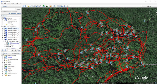
In addition to looking more closely at your hunting spots, you can gather a bunch of interesting and insightful information. Information that may help you find new spots in the future. If nothing else you can see some really fun overlay data to see what you decide to track. I pretty much just carry my phone with me running Trimble Outdoors, and I have a quick and easy shorthand for marking points to define waypoints as grouse or woodcock contacts, and whether they are foot flushed, dog flushed, or pointed birds. Also I've been throwing in whether a bird is downed or missed if shoes were fired. For example, WPK would be a Woodcock pointed and killed, GF would be a grouse dog flushed no shots, while a GFM would be grouse dog flushed and missed, and a simple G a grouse foot flushed with no shots. Using this shorthand when marking bird contacts has allowed me to collect data for many of my outings including points, wild flushes, birds killed, etc.. Just from a statistical standpoint it's pretty neat, but being able to pick apart a spot can be extremely helpful for improving future hunts. The spot shown below is one of our favorite spots loaded into Google Earth from the Trimble data. Represented is a handful of our trips over the 2015 season in this specific spot along with all tracks and bird contact points.
 |
| Overhead image of one of our spots after loading them into Google Earth. What you're looking at is several hunts through the area with walked tracks in red and all the waypoints representing bird contacts. Given "W" means woodcock, pretty woodcocky huh?? Notice the Grouse ("G") points and how they're clustered in specific areas. Hmmm. |
Also, depending on your level of detail in recording flushes, you can uncover an abundance of fun and useful data. For example, using my trip data from Trimble Outdoors I calculated for a specific number of days during the 2015 season I hunted 44.75 morning hours for 252 bird flushes, and 20 evening hours for 90 bird flushes, in addition to data related to species, missed birds, killed birds, points, dog flushes, wild flushes. All of this from just popping up a quick shorthand waypoint when the dust settled after a bird flush. I'm sure some people are not interested in plotting flushes, but to some it can be a very interesting if not valuable exercise during your hunting season. Not only have I enjoyed keeping track of the data over the last few seasons, but I always seem to discover a couple spots from the GPS that I forgot about that will be first on my list come September!
-Aaron R


Thank you for outlining the system you use to plot and record your flushes. I have a new puppy that I can’t wait to get out in the Grouse woods this fall. I have plotted all my hunting spots in my GPS app and have walked many of them already in the off season but can’t wait to get in there with the dog and see what we can find.